The Challenge of Flying Ingenuity On Mars
Between the first flight of Ingenuity and its current position over 12,000 meters away from its original landing site, NASA has learned a lot. This not only includes valuable data relative to Mars but also information about the helicopter itself and exactly what it’s capable of. The agency has also tested Ingenuity’s limits and found a few limits that it has.
With plans to use more helicopters in the future for a handful of Mars operations, these constraints they currently deal with will play a very important role. For example, the role Perseverance plays and the radio link between the two which is necessary for Ingenuity’s operation. In a few past flights, this has come up and has almost been a significant issue.
Especially considering the rocky and mountainous terrain of Mars, it creates quite a few challenges with communication and keeping Ingeunity in the air. Here I will go more in-depth into why it’s so hard to fly Ingenuity, the importance of communication, the impact of the Martian terrain, and more.
Loss of Communication

During Ingenuity’s 17th flight, after the helicopter executed the planned 614-foot (187-meter) traverse to the northeast, the radio communications link between Ingenuity and the Perseverance Mars rover was disrupted during the final descent phase of the flight. Approximately 15 minutes later, Perseverance received several packets of additional Ingenuity telemetry indicating that the flight electronics and battery were healthy.
All available telemetry during and after the flight suggested that the activity was a success and that the loss of link was due to a challenging radio configuration between Perseverance and Ingenuity during landing. The telemetry cut out during the final third of the descent, roughly 10 feet (3 meters) off the surface. At this point, NASA wasn’t exactly sure what caused this disruption.
A few days later the Ingenuity Mars Helicopter relayed additional information on its status. The limited data that was received indicated power aboard the rotorcraft is excellent, which suggests it was in an upright stance, allowing its solar array to efficiently power its six lithium-ion batteries. However, the same line-of-sight issues the team believes impeded communications at the end of Flight 17 still prevented the majority of data packets (including imagery from the flight) to be relayed back to the rover – and then to Earth. The next opportunity for a data transfer is expected to occur sometime within the next several days.
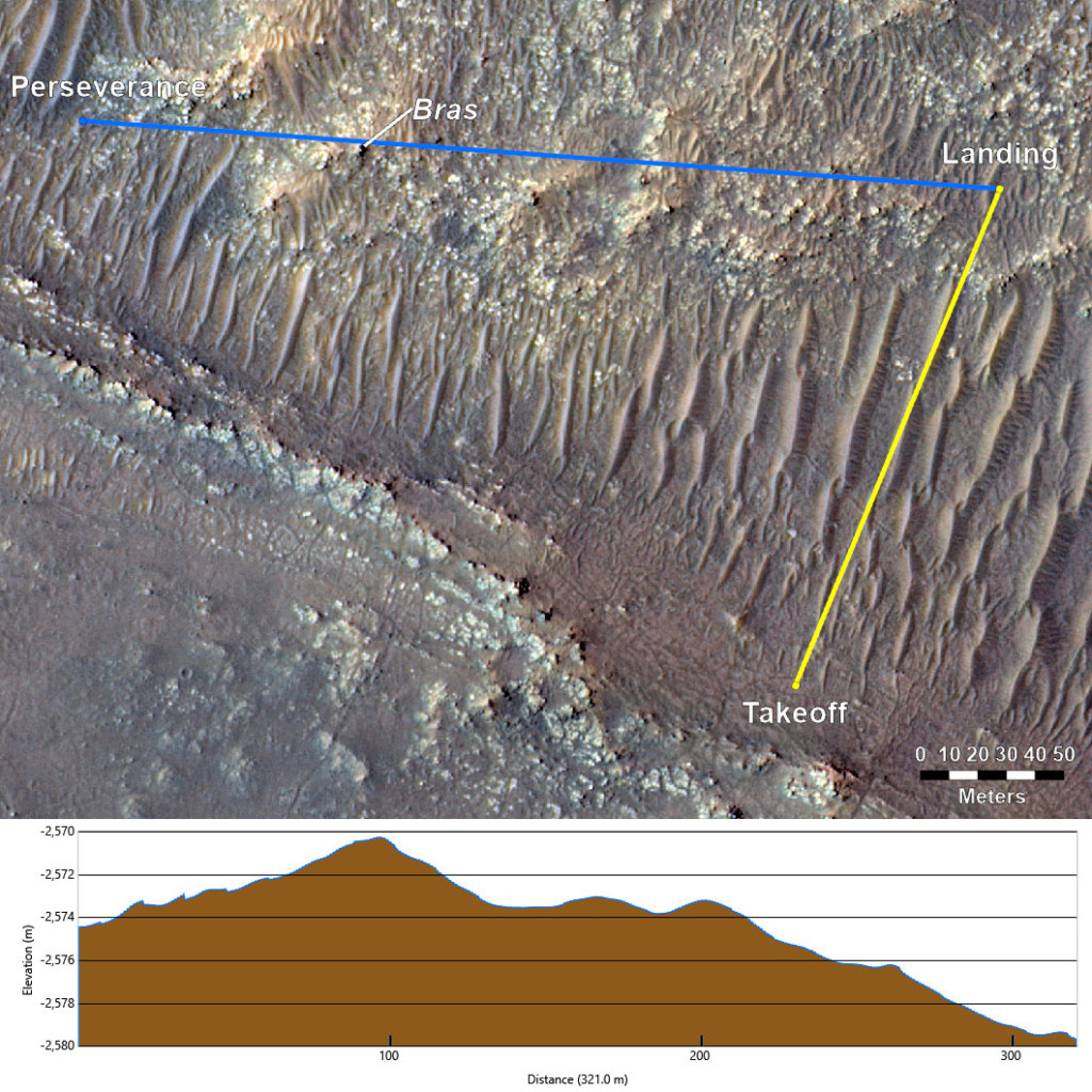
Soon after, engineers with the Ingenuity Mars Helicopter mission received enough additional data from the rotorcraft to confirm that the helicopter landed successfully at the completion of its 17th flight. During the two data transfer activities on Sols 285 (Wed.) and 287 (Fri.), the mission team maintained continual contact with the vehicle in its low-data-rate radio mode. The agency eventually figured out that the interruption in data communications between the Ingenuity helicopter and the base station on the Perseverance rover during Flight 17 occurred when the signal was blocked by elevated terrain between the two as Ingenuity descended at the end of the flight. Effectively, Ingenuity “flew behind a hill” or out of the rover’s line of sight, briefly interrupting high-speed communications between the two spacecraft.
In this image, Ingenuity’s flight path is depicted in yellow. Perseverance’s location is indicated in the upper left, with the blue line depicting its line of sight to the helicopter’s Flight 17 landing spot. The topographic map below indicates the altitude of surface features between the rover and the helicopter. This mountain was enough to interrupt the commucnation between the two only during the descent what Ingenuity was just above the ground. After this small scare the agency said, “as Ingenuity ventures farther and dares mightier flights in the future, we expect to again encounter loss of radio link on landing, similar to what occurred on Sunday. We will do all that we can in planning to prevent them (when possible), but temporary loss of radio link is a natural part of helicopter operations at the Red Planet.”
Trying to communicate with spacecraft on Mars is a difficult process that only gets harder when one relies on the other. Combine this with the speed and general requirements of both Perserverance and Ingenuity and its extremely impressive that the two are still side by side even today.
Radio Signal Disruption

A radio’s signal strength depends significantly on how clear the path, or line-of-sight (LOS), is between the transmitter and receiver antennas. That path can be obstructed by the ground itself if the helicopter lands in a depression or on the other side of a hill, or it can be obstructed by elements of the rover’s structure if the helicopter happens to be on the rover’s port (left) or stern (back) side. In this case not only was Ingenuity challenged with communicating across the rover’s structure and Multi Mission Radioisotope Thermoelectric Generator (MMRTG), but it was also tasked with flying to a landing site which placed a 13-foot (4 meter) hill. In the LOS between the two antennas. With a cruise altitude of 33-feet (10 meters), the hill presented little obstruction to the radio link during the majority of the flight. But as Ingenuity began to descend, the line of sight between the rover and helicopter antennas began to become obstructed/shadowed by the hill.
When they originally planned Flight 17, they believed that the rover was going to be parked in a specific location and oriented in a certain direction. However, Perseverance’s plans change day to day to maximize overall science return. By the time Flight 17 was ready for execution, Perseverance had driven to a new location and parked along a challenging heading for radio communications.
Since the start of the helicopter operations demonstration, they have accepted the potential for radio loss on landing due to the nature of their more challenging flights. Ingenuity was designed to handle these situations by automatically powering down after a flight and awaiting further instructions on subsequent sols, which they expected to be the case following Flight 17. These challenges are part of the lessons learned in integrating aerial exploration activities within the complexity of daily rover operations.
Ingenuity’s transition from conducting a technology demonstration to an operations demonstration brought with it a new flight envelope. Along with one-way flights, the plans included more precision maneuvering, greater use of its aerial-observation capabilities, and more risk overall. The change also meant Ingenuity would require less support from the Perseverance rover team.
With short drives expected for Perseverance in the near term, Ingenuity may execute flights that land near the rover’s current location or its next anticipated parking spot. The helicopter can use these opportunities to perform aerial observations of rover science targets, potential rover routes, and inaccessible features while also capturing stereo images for digital elevation maps. The lessons learned from these efforts will provide significant benefit to future mission planners. These scouting flights are a bonus and not a requirement for Perseverance to complete its science mission.
The cadence of flights during Ingenuity’s operations demonstration phase will slow from once every few days to about once every two or three weeks, and the forays will be scheduled to avoid interfering with Perseverance’s science operations. By now over 50 flights in, this process has been going very well.
Even recently on the 52nd flight, the Ingenuity team expected a communications dropout because a hill stood between the helicopter’s landing location and the Perseverance rover’s position, blocking communication between the two. In anticipation of this loss of communications, the Ingenuity team had already developed re-contact plans for when the rover would drive back within range. Contact was re-established June 28 when Perseverance crested the hill and could see Ingenuity again.
“The portion of Jezero Crater the rover and helicopter are currently exploring has a lot of rugged terrain, which makes communications dropouts more likely,” said JPL’s Josh Anderson, the Ingenuity team lead. “The team’s goal is to keep Ingenuity ahead of Perseverance, which occasionally involves temporarily pushing beyond communication limits. We’re excited to be back in communications range with Ingenuity and receive confirmation of Flight 52.”
At the core of this communication is the Deep Space Network (DSN). The NASA Deep Space Network is an international network of antennas that provide the communication links between the scientists and engineers on Earth to the missions in space and on Mars. The DSN consists of three deep-space communications facilities placed approximately 120 degrees apart around the world: at Goldstone, in California’s Mojave Desert; near Madrid, Spain; and near Canberra, Australia. This strategic placement permits constant observation of spacecraft as the Earth rotates on its own axis. Together these systems work to talk and communicate with spacecraft on Mars and beyond.
Conclusion
There are a lot of challenges when trying to communicate with technology all the way on Mars. Even hills can get between the rover and helicopter and cause issues of their own when the two can no longer talk to each other. We will have to wait and see how it progresses and the impact it has on the space industry.
